This Is Auburn Warning: Undefined array key 2 in /export/vol2/httpd/htdocs/academic/international/_includes/functions.php on line 86 Office of International Programs Service to the World
Global Teaching Academy
The Augmented Student Experience
  • Synchronous and Asynchronous use of technology (Licensed through AU or widely available)
    • Zoom, Skype, Office@Hand, Webex, Facetime, Other communication applications
    • Panopto video platform
    • Canvas – AU’s Learning Management System
    • Translation software – Language, Currency, Metric Units
    • YouTube
    • Adobe Creative Cloud tools
    • QR Coding for internationally themed portals
  • Remote use and manipulation of laboratory instrumentation
  • Use of Immersive Technologies
    • Online Communities (English or non-English based)
      • Microsoft Teams
      • Microsoft Flipgrid
      • Gaming communities and gamification
    • Google Earth, Google Maps
    • Google Liquid Galaxy
    • Remote Experiential Learning
      • Use of virtual tours of museums, zoos, aquariums, historic sites
      • 360° photos and video
      • Virtual and Augmented Reality
      • Avatar Teaching – Livestreamed immersive, 360o video using a surrogate
Jakita Thomas profile picture

Gaming/Gamificaton

Jakita Thomas, Philpott Westpoint Stevens Associate Professor, Computer Science and Software Engineering

  • Jakita Thomas’ popular course Game Design for Social Change is inherently international simply due to the mix of domestic and international students attracted to the subject. Using that student diversity as a springboard, Thomas assigns students to work in groups designing board and computer/mobile/video games that address an issue aligned with the UN’s Sustainable Development Goals. Students have designed games in that class that address a range of global issues from racism to female genital mutilation. The student groups brainstorm several game ideas as a group, which they present to the larger class and then the class votes on the idea they think is the best. Groups decide whether they want to pursue that game idea or another one of their ideas, which generates discussion about the ideas themselves and the culture and systems that surround the issue they want to address.
Stephanie Rogers profile picture

ArcGIS StoryMaps

Stephanie Rogers, Professor, Geosciences

  • StoryMaps allow you to take your students on a virtual adventure by exploring maps, images and stories from around the world. Whether the faculty member develops his or her own StoryMap depicting unique insights, data and educational material or whether students are tasked with using their creativity to display what they’ve learned, these interactive tools provide a way to visualize and make connections between facts and ideas. Stephanie Rogers’ Geographic Field Methods course allowed students to do just that.
  • StoryMaps Class Example.
Lacey Armstrong profile picture

360° Photos and Videos

Lacey Armstrong, Executive Director, Joseph S. Bruno Auburn Abroad in Italy Program

  • When students can’t be “there” in person, technology can still allow them to explore. The Joseph S. Bruno Auburn Abroad in Italy program is working to support home campus faculty and students by developing enriching content to add to their courses. Especially with fewer hands-on classroom activities available during the COVID era, Lacey Armstrong hopes the content they provide adds meaningful and engaging opportunities for students to explore the subjects they are studying through an international lens. Using ThingLink, Armstrong and her colleagues developed a virtual tour of the Ariccia campus to transport students to Italy. They also created a 360 video of the Trevi Fountain in Rome, with all the sights and sounds but without all the tourists.
  • 360 Video Around Trevi Fountain.
Andrew Gillespie with Aubie

Google Maps and Google Earth

Andy Gillespie, Assistant Provost for International Programs

  • Today, satellite imagery and aerial photography are widely available to explore landscapes and land uses across different parts of the globe. Andy Gillespie commonly uses Google Maps and Google Earth in his sustainability classes to provide students with examples of land uses that are uncommon or different in the U.S. from those found in other countries. Historical imagery and 3-D effects can also enhance the immersive experience for the students as they look through time and space at points of interest that help to bring international perspectives, both visual and intercultural.
  • Satellite image of terrain from Quebec, Canada via Google maps

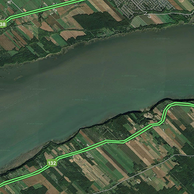
    The seigneurial pattern of land ownership, with narrow strips of land extending from rivers, once the primary means of transporting goods to market, can still be seen today in land use patterns around Quebec, Canada.

Lacey Armstrong profile picture

Virtual Tours

Lacey Armstrong, Executive Director, Joseph S. Bruno Auburn Abroad in Italy Program

  • Experiencing the food from another culture is a quintessential aspect of travel, and while Lacey Armstrong and her colleagues might not be able to provide students a literal taste of Italian food they have created an online culinary tour to transport students and inspire them to try their own dishes at home.
  • . Online Italian Culinary Tour
Last Updated: March 21, 2022